
Chapter 6 South East Coast
of Australia – 2023
Introduction
I started sailing along Australia's south-east
coast last century (not that long ago) and have
built up great local knowledge of both the
weather systems and the best routes north and
south along this coast.
When I headed south from the Whitsundays
returning home, I had the bit between my teeth
and, in true Malua style – after the Tasmanian
racehorse of the 1880s – I sprinted for the
finish. The passage south to Sydney from the
Gold Coast was fast, with a top speed over
ground (SOG) of 9.5 knots, so I was aiming to
top that speed with a little help from the East
Australian Current.
Going north, the best course is to hug the coast
and catch the counter currents, but sailing
south, the idea is to get into the current and
ride the flow south. The wind plays a part, of
course, so setting off with the wind in the north
is a prerequisite, but the strength depends on
the weather systems.
1

If there's a high-pressure system, you're safe,
but if there are any low-pressure cold fronts
down south and the wind may turn, you could
be holed up in a bay for a few days. The lower
the pressure of the front, the stronger the wind.
I had studied the winds for a few weeks while
sailing south and while in Sydney, so when I
looked at the 7-day forecast, I knew I had to
leave the next day because the wind direction
could change. The lesson here is don't only look
at the big picture, but drill down to the details
all along the passage because there may be a
smoother patch than you had noticed.
The Final Sprint Home
19 November, 2023
This sprint to the finish down the Australian
coast to Bermagui I have sailed more than 25
times, so I knew my way home, but did I know
the weather and what was waiting on the route?
The weather forecast showed that a good NE
wind would be blowing on the Saturday and
reach 25 to 30 knots during the nights, but it
was with me and the current was also in my
favour. The top speed on this cruise was 9.5
knots over the ground set off Port Stephens in
2

the last leg, and I knew I would easily do this on
this leg.
Now this leg is 160 nm at about 6 knots, which
would take a day and a half at most. I moved
from the Sydney Fish Market and sailed over to
Middle Harbour and picked up a mooring right
along the shoreline. The local yacht club was
having a sponsors race, so it was filled with
yachts and very smart crew not sitting on the
rail but holding a glass of the local bubble stuff
or some real champagne.
I had prepared a few nights' meals and tucked
into one as the sun set. Again, I set the alarm
for before dawn, and when it went off, I was off
and running with one reef in the main and a
poled-out genoa.
3
I soon cleared the heads and set a course past
Port Botany and directly to the Sir John Banks
shallows to the north of Jervis Bay. Now my
normal course going north is inside the banks,
and under normal conditions, I would go 5 nm
out to sea from the banks to get round the very
rough conditions associated with the great East
Australian current hitting the shallow banks
which come up from 120 m to less than 12
meters. You can imagine the turbulence as this
stream of water flowing from 2 to 4 knots hits
the shallow water of rocks.
I have passed this point many times before and
in many wind conditions, but this time was a
different experience. The wind had increased
and the waves built, while not ocean swell size,
4

were quite big but nothing Malua's autopilot
couldn't handle. The confused seas were
something else to behold. They seemed to
come from every direction, breaking over the
bow, stern, and even jumping on board from the
port side. A tug steaming north called on the
radio a similar company tug steaming south to
have a chat, then asked why he was so close to
the banks. They recommended he should turn
more out to sea. I was tracking him on the AIS
all the way down the coast, and immediately
after the communication, he turned off my stern
and headed out to sea for calmer waters. I
stayed my course.
I was committed, so I continued knowing Malua
was on a roll, and I had improved the top speed
record when I reached 10.8 knots SOG.
5
Decisions again. Should I continue and reach
Bermagui during the night? It was now 5:30
pm, so I would arrive at dawn or even pre-dawn,
and I would have to wait till the sun was up to
enter the Bermagui river mouth with a raging NE
wind and swell.
I, as always, took the prudent decision and jibed
at the entrance to Jervis Bay in the lee of Point
Perpendicular. While in flat water, I pulled the
main down and furled the poled-out genoa.
Then steamed into 25 knots of wind to the
northern shore of the bay at Long Beach to take
a break. I arrived after dark to find a catamaran
with all lights on and a much smaller sailing
vessel anchored near the shore. I have thrown
the pick in this area before, so I knew that one
6

had to drag the anchor in because it often got
fouled on sea grass. With the strong wind and a
depth of 10 meters, I let out the normal 40
meters and started to pull back on the anchor,
but it kept coming. So I hauled in the anchor
and immediately noticed the SQR had speared a
cockle shell right at the tip which was still
attached. That was the reason it wouldn't hold.
I moved up to the bow with the hammer to
release the shell and start again. Down went
the chain and I pulled back. The SQR and 50 m
of chain held, and I set the anchor alarm and
proceeded to get Malua ready for the next leg of
the journey.
Sleep and a good night's rest in calmer waters.
Alarm went off at dawn – no point in an early
start as I only had about 80 nm to run to
Bermagui. I checked the latest weather forecast
at BOM which indicated that the wind would
reach 35 knots along the Batemans and Eden
coast. The temptation was to wait and see what
the next day would bring. On this occasion,
prudence did not make a planning decision, but
when I set sail, I did put two reefs in the main
and furled the genoa on a pole well before I
exited the calm but windy Jervis Bay.
7
I flew out of the Bay and headed for a straight
line for Montague, knowing I would be about 10
nm offshore and well in the southern flowing
current and the ocean swells that accompanied
two days of strong wind. Little did I know what
the ocean had in store for me off Batemans Bay
and further south.
I had kept the boom on the starboard side as
the wind was from the NE, but as I sailed further
south, the distance from the coast got more and
more as I tried not to have to jibe in the current
conditions. Malua was handling the swell and
wind well, although it was obvious that I had too
much sail up and I was about to do a jibe.
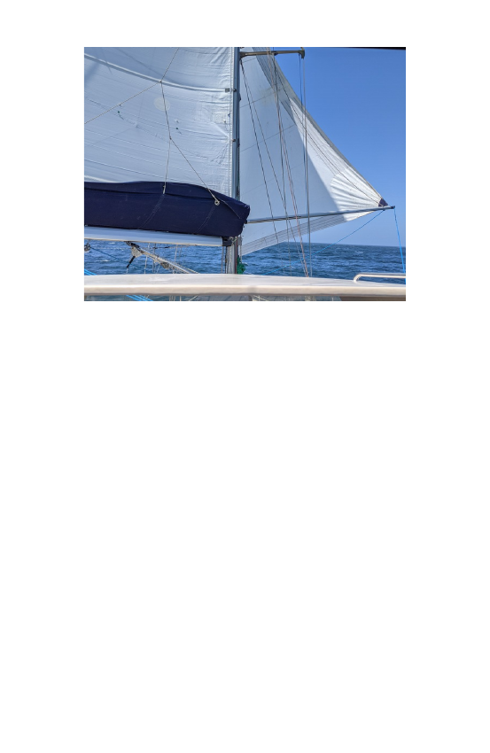
These are calmer conditions – see preventer
8

I prepared to jibe by undoing the preventer and
moving it to the port side, then started to pull
the main in via the electric sheet winch. At the
critical point, I turned the autopilot to turn to
starboard, and the wind got behind the sail and
it came over – not with the bang I expected but
with a gentle flop. Out went the sheet, I
corrected the course and connected the
preventer, and we were off and running again.
By this time, the waves had built to 4 or 5
meters. I know it's difficult to estimate the
height of the sea as one faces down a water
slope with the horizon almost completely
covered in spray, but on this occasion, I knew
the sea was big as a crest rolled down the hill
and right into Malua's cockpit. No water down
below (washboards in) but it wet my granny seat
and filled the cockpit!
The autopilot alarm went off as I sat in the
captain's chair and watched the dials and wind
speed indicator. On the second occasion, even
with two reefs in the main and no sail forward of
the mast, I knew we were over-canvassed.
What to do with only 40 nm to go to Bermagui?
So I stepped into the cockpit and took control of
Malua as we surfed down the face of the waves
and swell. I have not done this often and had
9

not realised the effort it takes to keep a long-
keeled boat on track with too much sail up.
Malua wanted to round up into the wind as we
reached the bottom of the swell, so one has to
anticipate what will happen. With all my effort
on the large wheel, I leaned on the spokes and
kept the bow on course and down the waves.
This continued for a while, and then the wind
started to ease, and the autopilot took over. We
settled down for the final straight to the finish,
but there was more to come.
What to do now was the decision to be made.
Continue to head for Bermagui and a potentially
dangerous bar entrance with seas breaking over
the entrance, or slow down and wait for either
the wind to drop or sail on to Eden? Now I am a
great supporter of technology, but my
confidence in NSW Maritime is very, very low, so
when I fired up the computer and switched to
the NSW Maritime Bar camera web site for
Bermagui and saw a small swell with about 17
knots of wind, I thought they must be playing
yesterday's video. I stuck my head outside and
yes, the wind indicator showed 35 knots of wind
and the sea and swell big, SO what was going
on? I again checked the Windy app at a more
detailed resolution and saw that there was a
10

patch of calm wind along the coast which I had
never seen before. What was going on?
I set a course close for Montague so that I could
drop the main in the lee of the island, but as I
approached the island, the wind started to drop
from 35 knots to 20 knots and then in the 15-
knot range. The Maritime bar camera could be
right. I phoned a friend. "Can you tell me what
the Bermagui bar is like?" Sorry, I am 20 km
away. My second lifeline did not answer, so I
thought maybe the Windy app was right. Is
there a pressure difference along the coast as a
system moves north? Take a chance and go for
it.
About one mile off the entrance, I turned up
wind into 12 knots of wind and a moderate sea
and swell and took the main down, furled the
genoa and staysail, and put in the washboards
again to cross the bar. I have a course which I
have used in these situations which takes a
curve towards the beach then moves west of the
leads and comes in as close to the western
break-wall as I feel safe. I adjust my speed to
try to time a lull in the swell. I saw my chance
and increased the engine revs and held the
wheel with both hands as I aimed for my entry
course. As I passed the headland, I looked up
11
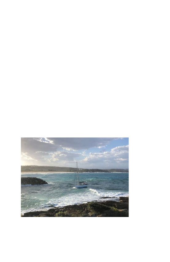
and saw a few people standing watching me
enter. Peter S was holding his camera. The
below photos are thanks to Peter. One of the
most dramatic shots of Malua that has been
taken.
I entered the harbour, lowered the fenders, and
made sure all the prepared docking lines were
ready and headed for my berth. A group of
friends: Jim, Keith, and Peter were ready to take
my lines as Malua nosed into her berth. We
were home. The whole trip had been a sailing
success with nothing on the boat breaking. A
great result. Malua had lived up to the
reputation of the great thoroughbred horse from
Tasmania.
Some final thoughts on storms at sea next.
12